


Amalfi
Amalfi entered the travel circuits only with the eighteenth century. All this because ...

Atrani
It is the urban centre with the highest density of population of the Coast and not for the high number of inhabitants but because it has a very small territorial extension. Urban structure, ascribable, according to some scholars, also to the toponym (Atrani< ater= oscuro) is characterized by houses built at short distance among themselves, on the contrary often they are built one on the other along Dragone torrent; this generates numerous small alleys and closed streets which are only used by houses of the area. Overlooking the sea, at a short distance from Amalfi, the centre shared fortune with it and in S. Salvatore di Birecto Church it hosted the election of the doge of the Maritime Republic.

Cetara
The living centre, settled at the river mouth of Cetus, has urban characteristics typical of the coast centres: houses located on mountainsides which form the boundary of the valley and watching towers in strategic points. The centre of Cetara explains, also analyzing the name ( Cetara > Cetaria = tunny fishing nets or Cetara = fish sellers), the economic vocation dedicated to fishing. Here it is produced, together with other tuna fishing and anchovy derivates, the famous “colatura di alici”, descending from ancient garum. Wise hands and orally transmitted knowledge transform fish into a tasty dressing for delicious dishes.

Conca dei Marini
Tradition wants that the village was the meeting place for “ianare”, a kind of witches who were able to fly on fishermen boats and to reach also far away places. Situated in the middle part of the whole coast, its name should come from the shape of the bay on which the lower part of the municipality opens. White houses which characterize the centre and the disposition along the mountainside S. Angelo a tre pizzi make Conca a village on a visitor scale who is welcomed by the majestic massive building of S. Rosa Monastery, once a feminine Monastery whose nuns, it is said, that had invented the famous “sfogliatella”, whose sweet and tasty paste is rolled up by a soft or crispy pastry.

Furore
It is defined “the village that doesn't exist” and “the painted village”; these definitions involve the essence of its urban structure. Houses are dislocated on various cores and there isn’t a proper centre and the external walls are decorated with murals of contemporary artists. Blue, pink, yellow and white of houses, of walls along the streets and of handrails mix themselves with nature colours: blue of the sea, sky-blue of the sky, white of clouds. The name of the village refers to another of its characteristics, in fact Furore has to be linked to stormy sea noise generated in the deep fjord which opens itself at coast level. The fjord walls preserve another beauty, this one is anthropic: ancient “monazzeri”, that are recover houses for fishermen who lived in the fjord to carry out their activity.

Maiori
The urban centre with more beach than the whole Coast, has a strong attraction for those who want to live the territory as a seaside resort. The village changed after the devastating inundation dated 1954, when Reginna river brought devastation because of mudslides. Houses were rebuilt and the river resettled but gardens cultivated with sfusato lemon were lost and also sand dunes which surrounded beach. Today Maiori is the departure point for several sightseeings both along the coast and towards hinterland since it is situated at the exit of the natural pass towards agro-nocerino where there are the archeological witnesses of Pompei, Ercolano, etc.

Minori
At the mouth of Reginna Minor torrent, the centre gathers in the valley around the ancient centre of the roman villa which testifies first attending periods of the site. One of the best preserved archeological witnesses of the Coast, the villa shows witnesses concerning ancient life thanks to its small thermal complex, to the precious nymphaeum and the garden which hosts shows during summer time. Standing out with other coast centres in the past for pasta production and lemon trade which left from here by ships towards Italian and foreign seaports, today it offers visitors a particular product “ndundero”, a kind of very tasty gnocco, a traditional dish in occasion of the patronal festival of Saint Trofimena.

Positano
The village, famous all around the world for clothes production, the typical “pezze” made of natural fibres and coloured textiles, represent the paradigm of several Costiera Amalfitana centres: it made the whole world fall in love with Positano when it was only a fishermen village, with few houses situated on the mountain which gets as far as the beach, and then it changed into the queen of international destinations. But it is still possible to taste old Positano atmosphere avoiding most crowded periods when perhaps also rain and stormy sea keep away those who only look for taking a picture of the most famous world view. Interesting to be seen is the roman villa, recently discovered which reminds us the beginning of this coast centre.

Praiano
Set in a bay, the village is divided in two parts by the state highway which crosses horizontally the whole Coast but on the horizon it embraces some of the most beautiful views of the world: Capri, little isles de Li Galli and the next Positano appear, at sunrise and at sunset, in the same natural way they appeared before they were involved in tourism. Crossed by “Dei Path” reachable by different link roads, in the high part, it offers the visitor a particularly interesting place of faith: S. Maria del Castro Convent, situated 364 meters above sea level, to which an ancient tradition is linked, la luminaria di S. Domenico. On the first days of August, the village is lightened with candles and torches to remember the famous dream which came before the birth of the Saint.

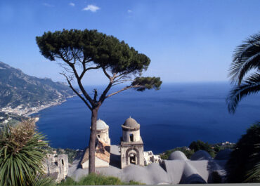
Ravello
Spreading on the level land delimitated on one side by Dragone torrent and on the other by Reginna Minor torrent, Ravello shows signs of the glorious past of places rich of merchants. Residence towers of the ancient Rufolo family (the history of one member of this family was the main character in one of the Decameron novels written by Giovanni Boccaccio), enclose the square on which overlooks the Dome, decorated by ambos, valuable mosaic art works. The beauty of the view, appreciable by Belvedere of Cimbrone villa, and quietness of the village, together with occasions of cultural amusement (famous concerts that take place every year in Rufolo villa gardens in memory of Richard Wagner sight in 1880), allow to live fully the territory.

S. Egidio del Monte Albino
The urban centre, at Albino mountain side, was already attended in the roman period (the crypt in S. Maria Maddalena in Armillis Abbey preserves ruins of a villa dated II century AD). it has typical features of centres dedicated to agriculture; houses gathered together around a courtyard to which often it is possible to enter through important portals, artistically carved in the local stone of Vesuvio, receive every year visitors during the event “I Cortili della Storia”. On this occasion in courtyards ancient jobs have a revival, and their representations are accompanied by traditional music and local wine and food dishes. Interesting to understand local history is also “Corteo Storico”, which recall the election of the Major that was held in 1500 for the first time.

Scala
In front of Ravello, Scala, (in its toponym there is evidence of its urban structure organized in 6 hamlets, once only linked through steps, a part from the real centre) with its castles (Scala Maior, Scalelle, Ziro tower) testifies the outstanding defensive function of hill and mountain centres for Amalfi Dukedom safety. Gardens and chestnut woods, whose very appreciated fruit gives life to a yearly festival, during which it is possible to taste typical dishes prepared with chestnuts but also cooking innovations, characterize the place view. Scala represents a good departure point for those who are interested to excursions on the mountain, since there are a lot of link roads which link the centre with Alta Via dei Lattari, and along this road it is possible to admire the most beautiful patches of the Costiera Amalfitana.

Tramonti
The centre, made of 13 hamlets dislocated along the valley that constitutes the natural landscape from Maiori towards Chiunzi pass, betrays its agricultural vocation and its roman origin. A lot of toponyms send back to ownerships concerning rustic holdings (Cesarano, Capitignano, Trugnano, etc.) that once had to represent rustic villas, and one of this survives in Polvica hamlet. That attending can be explained through the abundance of cultivable ground, less uneven compared to the other parts of the Coast, and good wood. The tradition to use branches and flexible parts of young chestnut trees to build baskets used to bring goods or cradles for newborns carries on also today in some craftsmen’ knowledge who carry on this activity and the one of farmers or smiths (iron working was a spread activity).

Vietri sul Mare
It has always been nearer to Salerno than to Amalfi, the centre of Vietri is well-known for pottery art, whose tradition dates back to Middle Ages. The ability to work clay to create daily use kitchenware met artistic inspiration of both local workers and foreigner painters who had reached the Coast because attracted by beauty of the places, and then remained and acted together with local people, transforming products from simple home use to art masterpieces. Nice are majolicas there is no church of the Coast which has no floor with them, and typical plate service with natural colours and with decorations which contain typical subjects of the coast.

Corbara
The municipality, situated on the northern versant of Lattari Mountains, expands at the foot of Chiunzi mountain, presenting an urban planning model typical of municipalities located at the foot of mountains. In fact, crossing country road 2 which from Chiunzi pass brings to Vesuviana plain and to big highways links, the municipality lays around to a principal core which has its centre in S. Bartolomeo church and it presents numerous spread houses because of the agricultural vocation of the urban centre. The municipality history has its roots in the roman presence before Christian period. In fact the nearness of big centres of Nuceria and Pompei defined these places as the part of the territory dedicated to agriculture; that situation is witnessed by the presence of archeological discoveries. The municipality appears for the first time in a document dated 1010 and it gravitated in the politic and religious area of the next municipality of S. Egidio del Monte Albino (above all S. Maria Maddalena in Armillis abbey had great influence on Corbara). From the cultural point of view it is interesting the traditional “Descend of the Angel”, yearly event which reminds S. Erasmo’s release, co-titular of the principal village church, from the martyrdom which deeply roots in a typical practice of local people who cut wood, who were used to make descend cut logs from the mountain as far as the village, keeping them linked to rudimental rope-ways. Corbara represents a good departing point to catch the countrymen dimension of Unesco site, thanks to the presence of the typical production of “corbarino”, a small tomato which can be preserved for a long time and which is kept in bunches in fresh cellars of the area. Here it is also possible to find the preservation of citrus fruits in grottos fresh for the whole year, since the abundant production allows to preserve them fresh in grottos situated in gardens that here are much wider than those of the coastal area.